Ethan Cole

For accurate altitude readings, consider using barometric pressure instruments. These devices utilize changes in atmospheric pressure to determine elevation above sea level. When ascending, the pressure decreases, which is measured and converted into height. As a rule of thumb, atmospheric pressure drops by approximately 1 inch of mercury (Hg) for every 1,000 feet in elevation gain.
To ensure precise results, calibrate your device before use. This is crucial, as local weather conditions can significantly impact readings. Reset the altitude setting to a known elevation or sea level reference point before embarking on your ascent. Additionally, maintaining awareness of current weather patterns can improve accuracy, as storm systems can alter pressure readings.
Keep in mind that these instruments may require periodic adjustments based on environmental changes. Tracking trends in pressure can also aid in predicting changes in altitude, allowing for a more informed outdoor experience. By understanding the relationship between pressure and altitude, you can leverage these tools effectively for hiking, climbing, and aviation purposes.

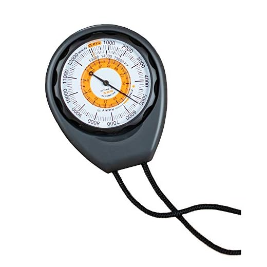
Principles of Altitude Measurement in Timepieces
Altitude measurement relies chiefly on atmospheric pressure variations, as pressure decreases with increasing elevation. This principle forms the foundation of many devices designed to track altitude changes. Timepieces equipped with this feature employ a barometric sensor to capture real-time changes in surrounding air pressure.
When elevated, the sensor detects a drop in pressure, which is translated into altitude. Each unit drop in pressure corresponds to a specific height increase, typically at sea level. The device must be correctly calibrated, factoring in the weather conditions, as fluctuations in atmospheric pressure can mislead readings.
To enhance accuracy, some advanced models incorporate built-in algorithms that adjust for temperature variations. Temperature can also affect pressure, leading to erroneous altitude estimations if not compensated. Regular calibration against a known elevation can aid in maintaining precision.
Users can further improve reliability by manually resetting the device to a known altitude point before critical activities, such as hiking or climbing. This recalibration process ensures that altitude measurements remain dependable throughout the experience.
Barometric Sensors and Their Functionality
Barometric sensors rely on the measurement of atmospheric pressure to determine altitude changes accurately. When pressure drops, altitude increases, allowing the sensor to give precise readings. Advanced models utilize digital signal processing to enhance measurement stability and reduce noise.
Types of Barometric Sensors
Different types of barometric sensors serve various applications, including:
| Sensor Type | Application |
|---|---|
| Analog Pressure Sensors | Basic altimeters, simpler applications |
| Digital Pressure Sensors | Smart devices, where precision is crucial |
| MEMS Pressure Sensors | Compact devices, including portable electronics |
Functionality of Sensors
The core functionality involves detecting changes in air pressure. When ascending, the pressure decreases; conversely, during descent, it increases. This principle enables the calculation of altitude. The sensor’s readings can be adjusted for temperature variations, enhancing accuracy.
Calibration is necessary to adapt to local pressure conditions. Many devices allow users to set a reference altitude, which helps refine measurements and account for daily atmospheric changes. Regular updates to firmware also contribute to maintaining accuracy over time.
Calibrating Your Device for Accurate Readings
Begin calibration at sea level or a known reference point. Ensure the current barometric pressure is noted accurately before adjusting your instrument. Most devices allow for manual input of this value, which should match the local atmospheric pressure on a clear day.
Regularly check the calibration before significant activities such as hiking or mountaineering. A simple way to verify accuracy involves comparing readings with a trusted source, such as a GPS unit or an established altitude marker like a topographic map.
Adjust for changing weather conditions since atmospheric pressure can fluctuate. Periodically recalibrate to account for these variations to enhance precision over time. An awareness of local meteorological forecasts may aid in anticipating those shifts.
If fluctuating readings occur, try resetting the calibration in proximity to fixed altitudes–such as summits or peaks where elevation is well-documented. Always keep an eye on short-term weather changes that could affect measurements, adjusting as necessary.
Make use of altitude logs if available, recording discrepancies for future reference. This data helps identify patterns in measurement accuracy and provides insight into ideal calibration intervals based on past activities.
Impact of Weather Changes on Altimeter Performance
Changes in atmospheric conditions can significantly affect the accuracy of elevation measurements. Frequent calibration is necessary before major outdoor activities, especially in regions where weather patterns shift rapidly.
Pressure Variations
Barometric pressure fluctuations directly influence the readings of elevation measurement devices. Higher humidity typically results in lower air pressure, which can cause the instrument to report a higher altitude than the actual one. Conversely, a drop in humidity often leads to more accurate readings. To mitigate the impact of pressure changes, sensors should be regularly adjusted based on local weather data.
Temperature Influence
Temperature variations also play a significant role. A decrease in temperature often correlates with an increase in air density, leading to discrepancies in altitude calculations. In colder conditions, the device may indicate a lower elevation than actual. Therefore, monitoring temperature changes is critical for maintaining precision. Adjustments based on temperature readings should be made to ensure reliability.
Comparing Barometric and GPS Altimeter Technologies
Barometric and GPS measurement systems each have unique characteristics and use cases. Understanding these differences is crucial for choosing the best tool for altitude determination.
Barometric Measurement Advantages
- High accuracy in stable atmospheric conditions.
- Immediate response to changes in elevation.
- Better performance in environments without satellite visibility.
- Low power consumption, extending battery life.
GPS Measurement Advantages
- Global coverage, useful in remote locations.
- Not influenced by local weather conditions.
- Can provide user location in three dimensions (latitude, longitude, and altitude).
- Useful for tracking elevation changes over large distances.
Both systems can be affected by specific limitations: barometric variants may malfunction due to changing weather, while GPS can offer less precision in foliage-heavy or urban areas. For the highest accuracy, utilizing both systems in conjunction provides the best of both worlds. Adjusting a barometric mechanism for altitude using GPS data can lead to more reliable readings in varying conditions.
Practical Tips for Using Your Altimeter in Outdoor Activities
Before heading out, calibrate the device at a known elevation, such as starting point or parking area. This ensures readings are accurate throughout the outing.
Monitor Weather Changes
Be aware that atmospheric pressure fluctuations can lead to incorrect altitude readings. If there’s a significant change in weather, make adjustments or take note of the potential inaccuracy in your elevation data.
Track Elevation Gain
Utilize the elevation gain feature to track ascent during a hike or climb. This adds important context to your journey and aids in planning the return trip, where elevation may impact energy levels and time.
Regularly check the barometric trend and note any rapid changes. Familiarity with how conditions influence altimeter readings can enhance decision-making regarding safety and progression during activities.
Use altitude data in conjunction with maps for navigation. Understanding the relationship between physical terrain features and your recorded altitudinal changes can improve route planning and situational awareness.
Keep the device protected from elements like moisture. Even slight water exposure can disrupt sensor functionality and lead to inaccurate readings over time.
If participating in high-altitude excursions, familiarize yourself with the risk of altitude sickness. Regular monitoring can help identify ascent-related symptoms that may require a slower pace or descent.
Lastly, document your findings post-activity. Reviewing elevation data can provide insights for future adventures, helping refine planning and strategy for similar outings.